The title of this blog isn't quite correct. We'll talk about the last two days in Peru first! The Inca Trail was very physically demanding, so no-one felt like too much strenuous activity for a couple of days afterwards. The trek had also made Fiona's cough worse so she spent the next two days in bed or on the sofa in the hostel recovering. The rest of us made a few short trips out to see other Inca ruins nearby and we all went out for a celebratory dinner with some of our new friends from the trek. We took the opportunity to try an alpaca steak, which was very tasty.
We left Cusco on a night bus and headed to the town of Puno on the edge of Lake Titicaca. We spent just a few hours there in the morning to visit the floating islands before crossing the border into Bolivia. The floating islands are constructed from large blocks of mud and reed roots, which are then tied together with rope and layers of cut reeds laid on top. These islands are surprisingly stable and the largest of which is big enough to build several reed houses on. The short tour to visit them by boat was interesting but a bit touristic and the interaction with the people who lived there a bit contrived.
After getting back on the bus and crossing the border into Bolivia, we arrived at the town of Copacabana (very different from the famous area of Rio de Janeiro with the same name). We (Fiona and Ben) had spent 25 days in Peru, which was the longest either of us has ever spent continuously in one country outside the UK. We were a bit sad to leave, but left with memories of great adventures and were excited about Bolivia.
There isn't much to do in Copacabana, but it is the place to catch a boat to Isla del Sol in the middle of Lake Titicaca. Lake Titicaca is a huge 160km long by 65km wide expanse of water that forms part of the border between Peru and Bolivia. It is also the highest navigable lake in the world at 3600m above sea level. It was odd to see so much water that it felt like a small sea, but in fact we were really high in the mountains. We spent the hour boat crossing bracing against the wind sitting on the roof of the boat. It was very exhilarating, if a little cold. Isla del Sol is quite small and it is easily possible to walk the length of it in one day. Unfortunately we had only 24hrs on the island so didn't have time walk there and back in a day. Instead we went for a short walk to see some of the island and enjoyed a great lunch overlooking the lake and back towards mainland Bolivia. We are finding that a considerable amount of time on this trip is just spent enjoying the view. We all felt we could have spent a couple more nights on the island exploring fully.


Isla del Sol on Lake Titicaca
Our final experience of the lake involved watching our bus being put on a concrete raft and floated across the narrowest part of the lake (less than 1km). We weren't allowed to stay on the bus and crossed in a small motor boat. Once safely on the other side we hopped back on and drove to the city of La Paz. At this point we realised that the infrastructure in Bolivia is not quite up to the standards of the countries we had visited so far. The main road from the border with Peru towards La Paz just seems to stop an hour short of the city. There used to be one, but they are currently in the process of digging it up to build a new highway. Unfortunately they have dug the whole thing up before starting on any of the new road so the journey was very bumpy and the views consisted of huge piles of rubble for many kilometres.
Gawaine and Ben got up early on the first morning in La Paz to cycle down the North Yungas Road a.k.a The World's Most Dangerous Road, a.k.a Death Road. The Rowe sisters decided they had more important things to do and didn't join in. Until 2007 over 200 people died each year navigating the single track gravel road on the edge of a cliff. This was mainly due to it being used for two way traffic including trucks and buses. It is not hard to imagine how a truck or bus filled with passengers plunges over the edge when trying to pass another on a road barely wide enough for one. Thankfully a new tarmac tow lane highway was opened with large vehicles now banned from using the old road. That said 15 people have still died this year. These deaths are due to a combination of stupid overtaking manoeuvres on around blind bends on the tarmac part of the road at the top and cyclists trying to take selfies and not looking where they are going. There are several monuments to those who have died along the route.

Having been kitted out with appropriate clothing (circa 1990), knee and elbow pads, full face helmet and a bike with good brakes we began the ride on a tarmac road high above La Paz. This gave us time to get used to our new bikes and appreciate the dramatic scenery. Although we took care to keep our eyes on the road and not get distracted by the view. An hour later the tarmac ran out and we diverted onto Death Road proper. After a slow start we gained confidence on the terrain and picked up some speed. The ride along the the gravel track was exciting and required concentration, but the ever present cliff edge and the scenery as we descended from mountain pass to jungle track made it even more exhilarating. 50km later we arrived at the bottom. We had survived the World's Most Dangerous Road!


Ready for action
Having been kitted out with appropriate clothing (circa 1990), knee and elbow pads, full face helmet and a bike with good brakes we began the ride on a tarmac road high above La Paz. This gave us time to get used to our new bikes and appreciate the dramatic scenery. Although we took care to keep our eyes on the road and not get distracted by the view. An hour later the tarmac ran out and we diverted onto Death Road proper. After a slow start we gained confidence on the terrain and picked up some speed. The ride along the the gravel track was exciting and required concentration, but the ever present cliff edge and the scenery as we descended from mountain pass to jungle track made it even more exhilarating. 50km later we arrived at the bottom. We had survived the World's Most Dangerous Road!

That's a big drop!

Braving the edge
Meanwhile Fiona, Hannah & Rachel visited the Valley of the Moon and the Witches Market where amongst many interesting items you can buy a dried llama foetus. It is traditional before constructing a new building in Bolivia to hold a small ceremony with a shaman and provide an offering to Pachamama (Mother Earth). In the case of a house or similar sized building a llama foetus is deemed a sufficient offering. Urban legend has it that for large buildings a human sacrifice is necessary. There are several tales and even a film about homeless people being plied with alcohol, invited to a party and then buried alive in the foundations of buildings. Hopefully this is just a story made up to entertain the tourists.
Leaving La Paz on yet another night bus we headed to Uyuni to begin our adventure on the famous salt flats. We had booked a 3 day tour of the Salar de Uyuni and nearby national parks. This would be our last few days as a group of 5 before Hannah, Rachel & Gawaine's holiday was over and they headed back home. The tour began with a visit to the train graveyard just outside town. Uyuni was founded as a rail hub for distribution of minerals from mines in the surrounding areas out to the Pacific coast. As Bolivia no longer has a coastline (Chile took the land in the Pacific Wars of the late 19th century) and depletion of mineral reserves, the trains were largely abandoned in the mid 20th century.


Leaving La Paz on yet another night bus we headed to Uyuni to begin our adventure on the famous salt flats. We had booked a 3 day tour of the Salar de Uyuni and nearby national parks. This would be our last few days as a group of 5 before Hannah, Rachel & Gawaine's holiday was over and they headed back home. The tour began with a visit to the train graveyard just outside town. Uyuni was founded as a rail hub for distribution of minerals from mines in the surrounding areas out to the Pacific coast. As Bolivia no longer has a coastline (Chile took the land in the Pacific Wars of the late 19th century) and depletion of mineral reserves, the trains were largely abandoned in the mid 20th century.

Uyuni train graveyard
We then headed out onto the largest salt flat in the world, the Salar de Uyuni, the bed of a huge prehistoric lake. It is a pretty odd landscape and it felt strange to be able to see the horizon in every direction with a featureless terrain in between. The salt has cracked into huge polygonal slabs and if you dig in the cracks between them you quickly find brine. It also makes for some great forced perspective photos!

Yorkshire, Yorkshire!

Jump!

Ouch!

Giant llama.....run!
We stopped off in the very middle of the salar to visit the Incahuasi island. This is a bizarre cactus covered rock that rises up out of the vast emptiness of white. Some of the cacti are hundreds of years old and can reach 10m in height.

Incahuasi

Sunset on the Salar de Uyuni
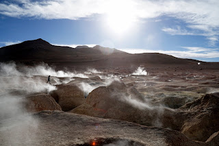
The first night was spent in a hostel literally made of salt on the edge of the salar. The walls, tables, chairs and even beds were all made from breeze block sized slabs of salt. As impressive as the salt flats were it was the rest of the trip that really took our breath away. We had naively just expected more of the same, but every 30minutes it seemed like we had arrived on a different planet as we drove along. There was sandy desert, green plains with llamas on, rocky scrub land, huge volcanoes, mountains, lots of flamingoes on a series of huge lagoons and finally fumaroles and boiling mud. The photos here give you a taste, but they can't really do justice to the incredible scenery we saw.

One of the many lagoons in the Siloli desert

Sunny but very cold

Flamingoes on Laguna Rojo

Fumaroles and boiling mud pots
We spent the second night of the tour, and the final one as group of 5, in a basic lodge near the Chilean border. We would say goodbye the following morning as we (Fiona and Ben) were dropped at the border post whilst the others returned to Uyuni then La Paz to fly home. After dinner that night we sat in the dark in natural hot springs enjoying the night sky. Without any light pollution and being at over 4000m there were so many stars to see. It was a memorable way to end our 3 week adventure with Hannah, Gawaine and Rachel, and our time in Bolivia.


