Our campervan was a 6 berth model based on a VW sprinter van chassis from the appropriately named hire company Britz. We had the bed above the cab while Sally and Ian had the bed at the back of the van. The spare 2 berths meant that we didn't need to turn the dining area into a bed every night and back to a table again for breakfast. It would have been a cosy fit for 6 adults and we were glad of the extra space. Ian drove the first leg out of Christchurch and across the Canterbury plains to the south. The plains were very dry and all the vegetation was much browner that we had expected. Huge sprinklers were in place in every field to ensure the crops got enough water and the grass was green enough for all the sheep. It turns out that the Southern Alps running along the spine of the South Island cause huge amounts of rain to fall on the west coast leaving the east coast in a rain shadow. Droughts and wildfires are not uncommon.

That afternoon Ben drove us past the stunningly blue Lake Tekapo and Lake Pukaki to arrive at our first campsite in Mount Cook National Park. The site was over 50km from the nearest town and we were surrounded by views of the Southern Alps and of course Mount Cook itself. We stayed for 3 nights doing hikes up countless steep steps to Sealy Tarns and along Hooker Valley past several glaciers. Over the course of our 3 weeks in the campervan we would mostly stay at campsites in scenic locations run by the Department of Conservation (aka the DOC). We were very impressed by the facilities (often basic, but clean and functional) at each site and the locations themselves. The DOC manages all of the National Parks in the country including the tracks and visitor centres in each. The tracks were always very well marked and we found plenty of interesting information on boards at the start of each major walk. The visitor centre in Mount Cook National Park was particularly interesting with exhibits on local flora and fauna, Maori history, a history of climbing in the region, glaciology, geology and mountain rescue.


After a great start to our outdoor adventures in New Zealand, we eagerly headed further south through Queenstown and Glenorchy to the start of the Routeburn Track. Queenstown is the famed adrenalin sports capital of New Zealand, and although we did spend time their later, we just drove through on this occasion. The Routeburn Track is one of nine 'Great Walks' in New Zealand, which means it is particularly popular and advance bookings are required to stay in one of the huts along the way. It is 32km long and crosses the Southern Alps via the Harris Saddle. It is normally hiked in 2 or 3 days taking in all the scenery along the way, although it can be done in an ambitious one day hike for the fit and healthy. As keen we were to give this a go, to drive between the two ends is a 300km journey, meaning we'd be a long way from our van at the end of the day. Instead we hiked in from the Routeburn falls end up to the highest point at the Harris Saddle and back down the way we came. The lower slopes are covered in amazing native forest consisting of beech trees, ferns and more moss than we had ever seen. Everything was green and covered in moss. Once above the tree line it started to rain and then hail, but we carried on enjoying the challenge and views, safe in the knowledge we had a cosy dry campervan to go back to at the end of the day. Had it been a small 2 person tent, I'm not sure we would have been so enthusiastic!


Ready for our road trip!
That afternoon Ben drove us past the stunningly blue Lake Tekapo and Lake Pukaki to arrive at our first campsite in Mount Cook National Park. The site was over 50km from the nearest town and we were surrounded by views of the Southern Alps and of course Mount Cook itself. We stayed for 3 nights doing hikes up countless steep steps to Sealy Tarns and along Hooker Valley past several glaciers. Over the course of our 3 weeks in the campervan we would mostly stay at campsites in scenic locations run by the Department of Conservation (aka the DOC). We were very impressed by the facilities (often basic, but clean and functional) at each site and the locations themselves. The DOC manages all of the National Parks in the country including the tracks and visitor centres in each. The tracks were always very well marked and we found plenty of interesting information on boards at the start of each major walk. The visitor centre in Mount Cook National Park was particularly interesting with exhibits on local flora and fauna, Maori history, a history of climbing in the region, glaciology, geology and mountain rescue.

Lake Tekapo with Mt Cook

Sealy Tarns and Hooker Glacier
After a great start to our outdoor adventures in New Zealand, we eagerly headed further south through Queenstown and Glenorchy to the start of the Routeburn Track. Queenstown is the famed adrenalin sports capital of New Zealand, and although we did spend time their later, we just drove through on this occasion. The Routeburn Track is one of nine 'Great Walks' in New Zealand, which means it is particularly popular and advance bookings are required to stay in one of the huts along the way. It is 32km long and crosses the Southern Alps via the Harris Saddle. It is normally hiked in 2 or 3 days taking in all the scenery along the way, although it can be done in an ambitious one day hike for the fit and healthy. As keen we were to give this a go, to drive between the two ends is a 300km journey, meaning we'd be a long way from our van at the end of the day. Instead we hiked in from the Routeburn falls end up to the highest point at the Harris Saddle and back down the way we came. The lower slopes are covered in amazing native forest consisting of beech trees, ferns and more moss than we had ever seen. Everything was green and covered in moss. Once above the tree line it started to rain and then hail, but we carried on enjoying the challenge and views, safe in the knowledge we had a cosy dry campervan to go back to at the end of the day. Had it been a small 2 person tent, I'm not sure we would have been so enthusiastic!

Sally & Ian at the start of the walk

On the way back from the top. (Orange dots are people)
One of the highlights of the South Island was our trip to Doubtful Sound. Despite the name 'sound' it is actually a Fjord (a long, narrow, deep inlet of the sea created by glacial erosion) and originally charted by Captain Cook as 'Doubtful Harbour' as he was doubtful he could navigate back out under sail if he were to sail the Endeavour into it. In Maori its name is Patea - 'The sound of silence'. Regardless of its name it is very remote and getting to it requires some effort. After a 1hr boat trip across Lake Manapouri followed by a 20km drive over Wilmot Pass we made it to the edge of the sound to embark on our 3hr cruise. Incidentally, Wilmot Pass is famed as being the most expensive road in New Zealand, having been built solely for the reason of getting construction equipment in to build the hydroelectric power station on the west arm of Lake Manapouri. Words and photos don't really do justice to the magnificence of Doubtful Sound. It is a huge expanse of water trapped between steep cliffs rising hundreds of metres above the water. The rainy, overcast day on which we experienced the sound only added to the atmosphere and created countless temporary waterfalls on the cliffs.

Spectacular Doubtful Sound
The next couple of days were spent eating a tasty venison pie in Te Anau, driving along the scenic Milford Road and a day hike up to Key Summit and Earland Falls - at the other end of the Routeburn Track to the walk we had previously done. We continued along the road, stopping at various points of interest along the way, finally arriving in Milford Sound itself in the late afternoon. All the day trippers from Queenstown and Te Anau were leaving, and the only accommodation was a small campsite so it felt like we had the whole place to ourselves for the evening. The following morning we took a cruise out on Milford Sound under clear blue skies. Famously Milford Sound is one of the wettest places in New Zealand receiving over 7000mm of rain a year (more than 10 times that of London). It was great to be able to see it under such fair conditions and provided a different experience to Doubtful Sound. The highlight was to see a large pod of dolphins swimming towards and then right underneath our boat.

The view from Key Summit

Milford Sound
After a brief stop in the picturesque Arrowtown where we learnt a bit about the New Zealand's 19th century gold rush, we headed for the west coast. We drove via the Haast Pass which was only opened in 1965 to provide a link from the west coast to the south. It is a long, twisty road through lush beech forest and along steep mountain sides. A very small car park for a waterfall along the road provided an interesting parking challenge for a large camper van. Careful manoeuvring with the other 3 passengers outside watching each corner was required resulting in more time being spent parking and un-parking than actually looking at the waterfall. Once on the coast we visited the dunes, dune lakes and swamps of Ship Creek before spending the night next to the beautiful Lake Paringa. There was so much driftwood washed up on the beaches that it formed natural abstract sculptures along the high tide mark.
The west coast is famous for its rain and unfortunately it arrived just as we reach Franz Josef Glacier. The glacier has retreated rapidly in recent years resulting in difficulty getting to the face of it as it is so unstable. On the day we were there the visibility was pretty poor and we could only just make it out through the rain and mist. We spent the rest of the day sheltering in the camper playing scrabble (Fiona claims her victory was her first ever) and sitting in the hot pools opposite our campsite.

The beach at Ship Creek
Further up the coast we visited the blue waters of Hokitika Gorge, walked through the bush along the shores of Lake Kaniere (Sally went for an early morning swim!) and saw the unusual pancake rock formations at Punakaiki Rocks. The countryside was lush and green due to so much rain and full of dairy farms. As we left the coast we headed along the powerful Buller River marvelling at the gorge along the way before stopping for the night at Lyell. This is the location of an old gold mine and walking through the forest we found the cemetery of the first inhabitants and remains of a huge rock crushing machine. A long distance mountain bike track called the Old Ghost Road starts here, but unfortunately we didn't have time for it on this trip. We also made friends with a South Island Robin who was very inquisitive hopping right up to us on the path and even trying to peck at our shoes to determine if they were edible.

Ripples in Lake Kaniere
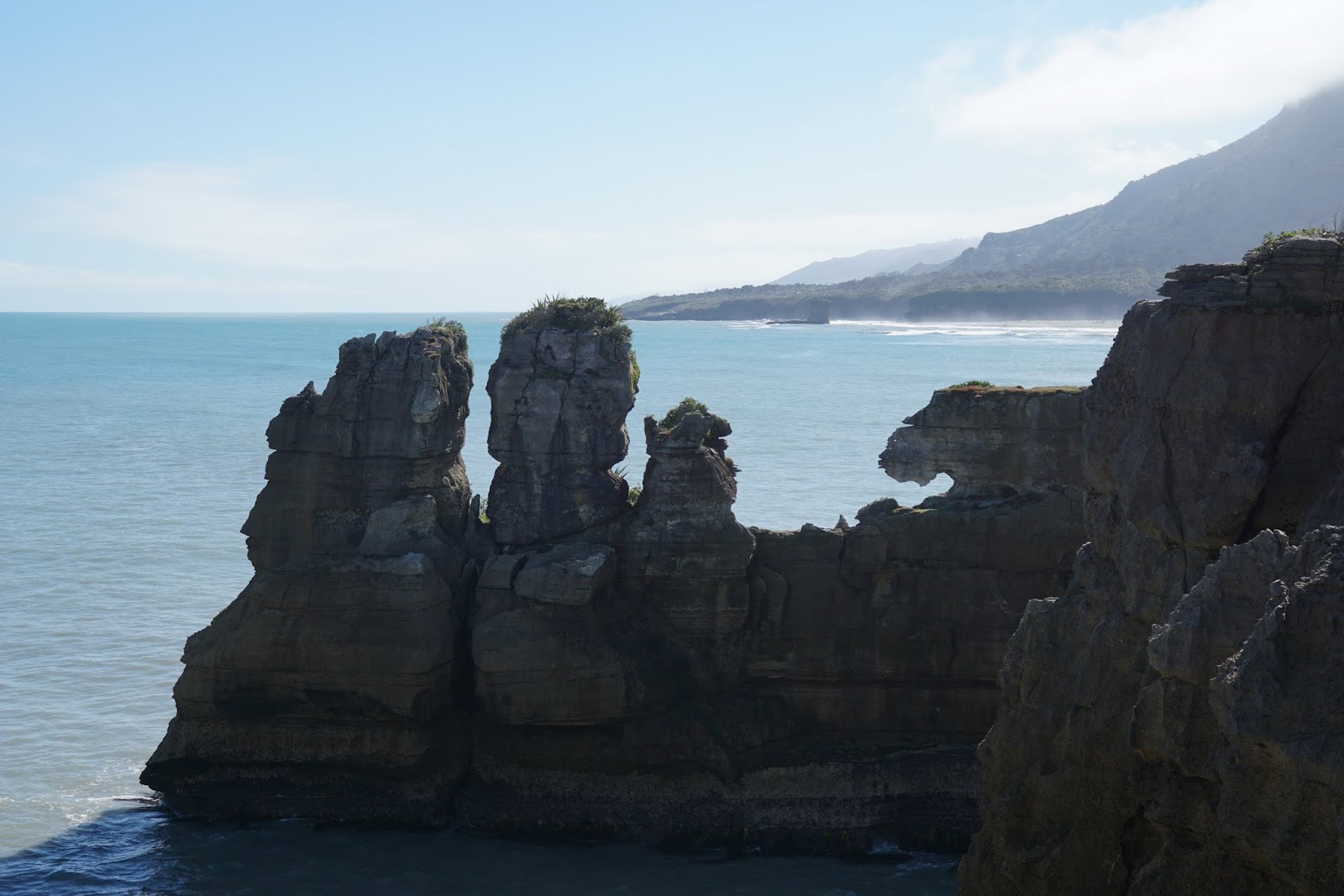
Punakaiki Rocks
Next we headed to the beach town of Marahau on the north coast of the island. The tidal range here is huge and the sea is hundreds of metres away from the shore at low-tide. As the tide turns you can watch the water continuously crawling along the beach as it comes in. We spent a day walking along part of the Abel Tasman Great Walk in the national park of the same name. We caught a water taxi 15km along the coast and then spent the day walking back, exploring streams and beaches along the way. The water taxi itself was particularly exciting as we all got on board the boat at the taxi office whilst it was still on the back of it's trailer. A tractor then towed us to the waterfront and reversed us into the sea.

Ben with the tractor

Golden sands of Te Pukata beach
Whilst in the area we explored a different part of the coastline in a Maori waka (canoe). It was a great way to see the national park from the sea and to learn a bit more about Maori culture and history from our charismatic guide.

Fiona with our waka
Ross (who we had stayed with in Christchurch) invited us to stay with him at his holiday home in Ruby Bay, which is very close to Abel Tasman National Park. The house is in a stunning location on a hilltop looking out over the bay towards Nelson with a beautiful garden. Ross treated us to a tour of the local area including vineyards, the trendy village of Mapua, the old fishing port of Motueka and the 'Resurgence'. Here a river just appears out of the ground in a deep pool and Sally once again went for a swim in the freezing water. Saying our goodbyes to Ross we headed south from Ruby Bay to return to Christchurch where our campervan adventure ended.
We had a great time on our 'South Island highlights tour' with Sally and Ian - and it was a real treat having the campervan with handy cups of tea at a moments notice whenever we stopped somewhere. It had also felt particularly luxurious to have not had to unpack and repack our bags for a whole 3 weeks (luckily everything still fitted in)! However, all good things must come to an end, and a smaller vehicle was calling us to explore the South Island further and fill in the gaps.
Stunning photos and an interesting trip report. Great work!
ReplyDelete